Geonections
Sort countries into four hidden groups.
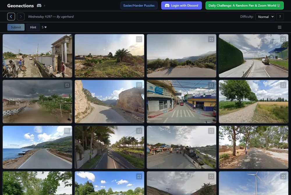
Geonections is a daily geography puzzle that asks you to sort 16 location images into four groups of four, with every tile in a group belonging to the same country. It takes the grouping format popularized by NYT Connections and swaps the words for GeoGuessr-style street and landscape photos. You get one puzzle per day, and the only way to solve it is to read the geography in each image.
What is Geonections?
The core loop is simple to describe and slow to master. You see a grid of 16 tiles, each showing a location image in the style of a street view or landscape shot. Four of them belong to one country, four to another, and so on across four countries. You pick four tiles you think share a country and submit them. Correct groups lock into a single color and reveal the country name, and you keep working the remaining tiles until the board is solved or you run out of chances. There is no typing and no map to click. You group by looking.
What sets Geonections apart from a plain Connections clone is that the clues are entirely visual and geographic. Instead of spotting a word category, you read landscapes, architecture, terrain, road markings, and street signage to work out which country a photo comes from. It rewards the same instincts that GeoGuessr players build up: recognizing the color of a license plate, the style of a bollard, the script on a sign, or the vegetation on a hillside. The puzzle sits in the overlap between those two games, which is where its name comes from.
The game offers three difficulty modes so the same daily board can be as forgiving or as punishing as you want. Easy allows unlimited mistakes and includes a give-up option. Normal limits you to five lives. Expert is the strict version: you get two lives, you have to submit all four groups at once, and one tile is left blind with no image at all, so you have to place it by deduction. Each mode gives you two hints, and using a hint lets you click a tile to reveal the continent it comes from. The settings let you toggle tile numbering, group-color tags, and a compass. An archive of past daily puzzles is available if you want to replay older boards.
One more quirk worth knowing: the puzzles get harder as the week goes on. Monday is the gentlest board, and the difficulty climbs each day toward Sunday, which is the toughest. The site does not list a creator name, a launch date, or a contact channel, so those details are unknown. What is clear from playing is the vibe: it is a quiet, single-daily puzzle that fits alongside other -dle games in a morning routine, with enough difficulty range to keep both casual guessers and seasoned geography buffs engaged.
How to play Geonections
- Open Geonections at geonections.com.
- Choose a difficulty mode: Easy for unlimited mistakes, Normal for five lives, or Expert for two lives and all-at-once submission.
- Study the 16 location tiles and look for shared visual cues such as terrain, architecture, signage, and vegetation.
- Select four tiles you believe come from the same country and submit them; a correct group locks into a color and shows the country name.
- Use a hint to reveal the continent of a tile if you are stuck, and adjust settings like numbering or the compass to suit you.
- Solve all four groups before you run out of lives, then return the next day for a new puzzle or replay past boards from the archive.
Tips and strategy
- Start with the group you are most confident about so a wrong guess does not cost you a life on shaky reasoning.
- Read road details closely: line colors, bollard shapes, and the side of the road cars drive on all narrow down the country.
- Look at signage script and language, which often points to a region even when the exact country is unclear.
- Use vegetation and terrain as tiebreakers, since climate and landscape differ sharply between countries on the same continent.
- Spend a continent hint early on Expert mode, where two lives and the blind tile leave little room for trial and error.
- When two tiles look similar, group the rest first so the remaining four sort themselves into the last country by elimination.
Good to know
- Category
- Geography puzzle
- Resets
- Daily, one puzzle per day
- Cost
- Free to play
- Modes
- Easy (unlimited mistakes), Normal (five lives), Expert (two lives, blind tile)
- Lives
- Varies by mode: unlimited, five, or two
- Difficulty curve
- Monday easiest, Sunday hardest
- Archive
- Yes, past daily puzzles can be replayed
- Hints
- Two per game, each reveals a tile's continent
- Platform
- Browser, no download
Geonections FAQ
Is Geonections free?
Yes. Geonections is free to play in a browser at geonections.com, with no download required.
How do you play Geonections?
You are shown 16 location images and sort them into four groups of four, where every tile in a group is from the same country. You select four tiles and submit; a correct group locks into a color and reveals the country name, and you use visual cues like terrain, architecture, and signage to deduce each country.
When does Geonections reset, and is there an archive?
A new puzzle appears daily, one per day, and the boards get harder through the week from Monday to Sunday. There is also an archive that lets you access and replay previous daily puzzles.
Is Geonections like Wordle or Connections?
It shares the once-a-day format of Wordle and the grouping mechanic of NYT Connections, but the tiles are GeoGuessr-style location images instead of words, so you group by country using visual geography rather than text.
Who made Geonections?
The creator is not listed on the site, so the developer and launch date are unknown.